In 1953 two men discovered a large rock near Renfrew inscribed with an apparently 400 year old message from Samuel deChamplain. We found the rock this summer and studied it more closely…
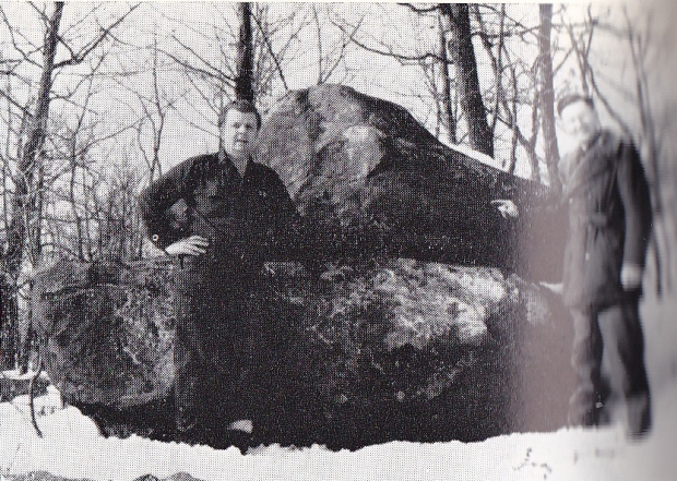
Over 400 years ago the famous explorer and geographer Samuel de Champlain mapped out a course through the uncharted territory of the Ottawa Valley in an effort to reach the Northern Sea. His journey up the Ottawa River in 1613 lead him through what is now Ottawa, the Chaudiere Falls, Lac Deschenes, Chats Falls and portaged lands beyond. Champlain’s quest up the Ottawa River took him as far as Pembroke where his journey ended and he turned back. This journey was documented by Champlain in his journal and later mapped out by him in 1632. This famous “Champlain Trail” was later substantiated when a French astrolabe, presumably Champlain’s, was found near Cobden in 1867, which is now on exhibit in the Canadian Museum Of History. Then in 1953 two men discovered a large glacial erratic stone on top of a hill near Renfrew with a large stone near its peak with an inscription carved into a flat side of the imposing rock. The carved letters spelled out “CHAMPLAIN JUIN 7 1613” .

The Champlain Stone and the two men who discovered it in 1953. (photo from “The UpperOttawa Valley” by Clyde C.Kennedy)
The stone was later deemed a hoax because 17th century French placed the number date ahead of the month, and used an “I” as the first letter of the month instead of a “j”. It was thus deemed a mysterious hoax, with no one ever confessing how or why they made it. The Champlain Stone was soon forgotten and it once again became lost in the deep woods from whence it was found. It is this mysterious stone of Champlain that I sought out to find once again, and examine it myself in more detail, hopefully shedding more light on this remarkable piece of Canadian folklore.
FINDING THE STONE
The stone was originally found in 1953 near Renfrew on top of hill located off the Ottawa River. Using a map from the excellent 1970 book “The Upper Ottawa Valley” by Clyde C. Kennedy from where I read about the Champlain Stone, I was able to overlay the 1970 map on a current map of the area to get a rough idea of where the stone was located.
Packing a rucksack and camera my girlfriend and I headed into the forest and began our climb through this terribly mosquito infested forest. Using the 1953 photograph of the Champlain Stone discovery, I had an idea of what it may look like, but was prepared for years of vegetation to conceal our prize. After about an hour of fruitless searching and 200 mosquito bites, I finally came across a rock that resembled the one in the 1953 photo. Holding the photo up to the rock, it was determined to be a match. We had found the mysterious Champlain Stone.
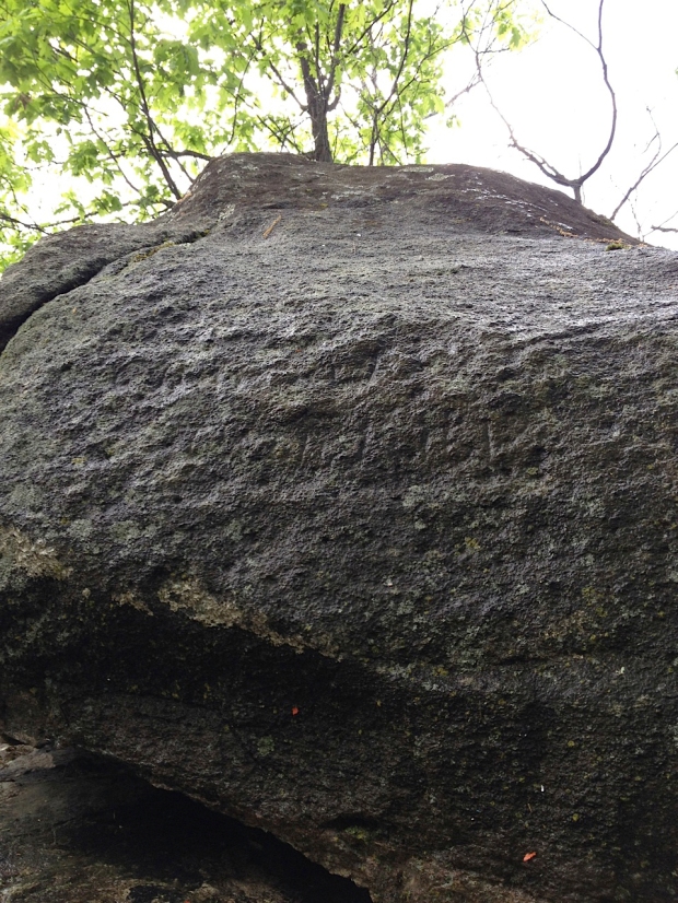
An initial inspection of this large stone revealed a definite carved inscription on one of the flat sides of the glacial erratic. Covered in lichen, it was impossible to make out what exactly it said, but pouring a bottle of water over the rock inscription brought out the detail in the lettering more clearly which was then photographed and studied. Measurements were made and we returned back through the forest to our car.
ANALYSIS OF THE CHAMPLAIN STONE
The Champlain Stone is an impressively large pair of boulders that balance on top of one another. It is a unique rock formation that stands out among the other nearby forest features. It is about ten feet in length and 8 feet tall. The inscription was made on the flat surface on the top stone. If you had no idea it was carved with lettering, you would not notice the inscription as it is covered in years of lichen growth. It was only when water was poured over the lettering did the letters become visible. Photographs did not pick up the lettering as well as viewed in person, so I have used Photoshop to overlay what I saw on the stone.

The inscription was hard to read, but using the outlines in the rock I have enhanced what was carved into the rock.
CHAMPLAIN’S ACTUAL JOURNEY
If we are to prove this Champlain Stone as a hoax, we must look at the actual documented journey of Champlain for comparison. His journey through the Renfrew area is a recorded and documented fact that occured in June of 1613. Champlain later mapped his journey along the Ottawa River and his portage to Pembroke on a map he made in 1632.
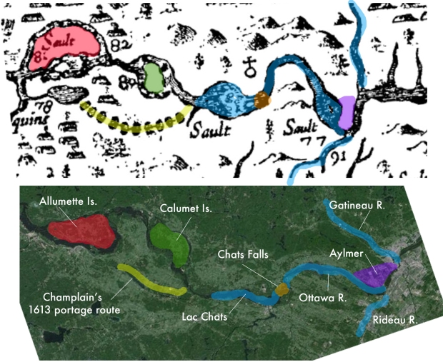
It is this 1632 map of Champlain’s that we will study and compare to the actual existing geography of the region. Leaving the Chaudiere Falls in Ottawa on June 4 1613, Champlain made his way up the Ottawa River with his canoes and native guides, making it as far as Chats Falls near Fitzroy Harbour. Here they portaged around the falls and made it to the Chenaux Rapids where they decided to portage west, through an area just north of Renfrew.

Comparing the 1632 map to a current aerial map, we can distinguish and use certain landmarks to establish Champlain’s route in 1613. Colours correspond to matching areas on each map.
It is at this point that details fade, and Champlain’s exact route is unknown. What is known, is that Champlain left the Ottawa River in an area called Brown’s Bay on June 6 to traverse overland following a string of lakes up to Pembroke. His journal makes account of travelling west: “Thus after having passed four small ponds and walking two and one half leagues, we were so tired that we could go no further…therefore we stayed by the edge of a pond, which was pleasant enough, and made a fire to drive away the mosquitoes which molested us greatly.” Champlain on the next day June 7, states in his journal entry “We passed this pond, which may have been a league long” and carried onwards towards Pembroke, losing his astrolabe near Cobden as he travered the difficult terrain. Studying Champlain’s 1632 map, I made some observations in relation to his journal entries. The map is actually a fairly accurate representation of the land and indicates prominent landmarks when compared to a modern satellite map of the same area (see diagrams) After overlaying his route with current maps, it is actually plausible that Champlain did indeed travel near the Champlain Stone on his portage, and the stone does actually in fact lie very near the shore of a large pond.
THE CHAMPLAIN STONE QUESTIONED
If the Champlain Stone is indeed a hoax, then why was it made and who did it? Comparing the map route of Champlain, it does put him in the area where the stone was found. It does lie on the shore of a pond that is mentioned in Champlain’s journal. It is a unique rock formation that stands out and would make a good landmark if one wanted to leave a record of your travels past it. The date inscribed on the stone is June 7, which also matches the date he would have been in that exact area according to his journal entries. If the stone is not authentic, then why would someone make a stone with an inscription in the deep woods with the hopes that someday someone would find it? How did the potential hoaxer know so much about Champlain and his journey to write the date of June 7 that exactly matches Champlain’s journal entry?
The Champlain Stone was never studied further or analyzed for authenticity, so it is unsure how long ago the letters were carved into the rock. Were they carved 400 years ago or were they carved 60 years ago? Without further study, we can not definitively prove its age. The Champlain Stone remains a mystery as to why and who would make an inscription on a rock deep in the Renfrew woods. Possibly some day someone will come forward with more information on this oddity, but until then, it sits silently forgotten, slowly being enveloped by the woods from where it was discovered. It remains a piece of an Ottawa puzzle that may never be solved.
SOURCES
The Upper Ottawa Valley: A Glimpse Of History Clyde C. Kennedy 1970
historicalatlas.ca
Google Maps


This is a great story and indeed would warrant more investigation. Thank you.
I have really enjoyed this piece. Another interesting find that may or may not pertain to Samuel de Champlain: http://bayoffundy.ca/archives/913
very cool…thanks for that link.
A good story, but as a Franco-Canadian, we always say «le 7 juin 2014», and never as inscribed. And, it is true that when Champlain was here, we did not yet use the J in French, only the I. mind you, another professional linguist`s opinion on this would be helpful, just to be absolutely sure.